In the geography section of China's university entrance examination, some people consider questions about Earth's motion the hardest, because they are among the few humanities questions requiring calculations. Others, including me, consider them the easiest questions in the entire humanities examination: they are the only ones we can confidently answer quickly and with 100% accuracy. Such questions may test local time and time-zone calculations, the noon Sun's altitude and changes in shadows, changes in day length, and sunrise and sunset directions.
Today, let us investigate time zones.
Earth's Motion and Social Development: Why Time Zones Are Necessary
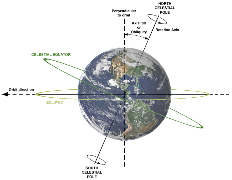
One hemisphere of Earth always faces the Sun, so theoretically half is always in daylight and half in darkness. Earth also rotates from west to east, causing day and night to alternate at different times around the world. With instant communication so widespread today, it is easy to know that when dawn breaks in Zhejiang, it has not yet broken in Sichuan; when Zhejiang becomes dark, Sichuan is still in daylight.
In antiquity, however, little attention was paid to this problem, mainly because there was no need. Sichuan and Zhejiang are about 2,000 kilometers apart. Even the fastest horseback journey took several days, while their local times differ by only one hour. That was unimportant, almost negligible. Each place could use its own sundial, or simply look at the sky; a rough idea of the time was enough.
Ancient China measured time in shichen. The noon period, when shadows were shortest, was wushi, equivalent to noon at 12:00 local time today. Other times were inferred by methods such as sundials and water clocks, probably without great precision. This was already highly advanced for an agricultural society. Ancient Greek and Roman scholars thought more deeply about the issue: they knew Earth was round and recognized time differences. Yet there was little practical application, because agriculture, trade, and governance then required neither such precise timing nor concern over time differences a thousand li away.
Only in the nineteenth century, with the development of railways—especially long-distance railways—did people encounter a problem: railway timetables needed to be standardized, but local time differed between stations. Resolving these differences and establishing time standards became an urgent human task for the first time.
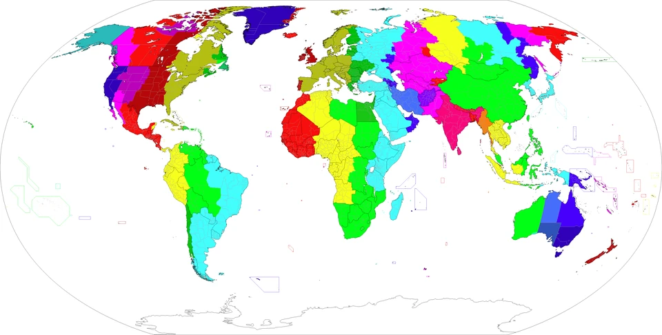
In 1884, the International Meridian Conference in Washington, United States, designated the meridian through Britain's Greenwich Observatory as longitude 0°. Its local time was set as standard time, Greenwich Mean Time, or GMT. Extending 7.5° east and west of this meridian defined one time zone. Each zone thus covered 15° of longitude and used the local time at its central meridian; neighboring zones differed by one hour. This is, of course, a theoretical division. Countries adopted different systems according to their circumstances.
GMT was originally derived from astronomical observations. After 1972, the international community adopted the more scientific UTC system—Coordinated Universal Time—using atomic clocks and leap seconds for greater precision. Time on today's internet comes through NTP, the Network Time Protocol, and is also linked to UTC. As long as your device can connect to the internet and accounts for your time zone, its time is therefore always standard.
How Different Countries and Regions Divide Time Zones
Time-zone calculation is simple: identify the two zones, adding eastward and subtracting westward. China, for example, is in UTC+8 and London in the zero zone, eight zones apart. Subtract eight hours from China's time to obtain London's. If it is 16:12 in China, it should be 8:12 in London. London uses daylight saving time in summer, however, advancing clocks one hour to the equivalent of UTC+1. China and Britain are thus currently seven hours apart, making London time 9:12 in that example.
The difficulty therefore lies in different national rules rather than the calculations themselves. Some countries have several times within their borders; some use winter and summer time, requiring clocks to be adjusted twice a year.
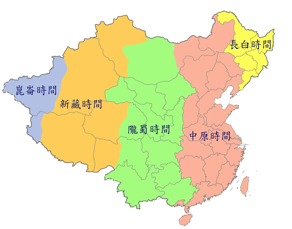
China's vast territory spans five time zones, from UTC+5 to UTC+9. During the Republican era, it once used a multiple-zone system dividing the country into five zones: Kunlun (+5:30), Xinjiang–Tibet (+6), Longshu (+7), Central Plain (+8), and Changbai (+8:30). This division reflected our large territory and let people follow traditional local schedules, but hindered communication between regions. Were it still in use, eight o'clock in Sichuan and eight o'clock in Zhejiang would be different moments, making communication troublesome.
Today, we uniformly use Beijing Time, UTC+8, greatly reducing the costs of interprovincial coordination and national transport and communications. Those of us in the west must accommodate it somewhat, but can adjust our routines using geographical knowledge. In Sichuan, for example, local noon occurs around 13:00. At the spring and autumn equinoxes, the Sun rises around 7:00 and sets around 19:00, so we can get up and go to bed a little later, though the overall impact is small. Following Beijing Time may actually encourage earlier bedtimes and rising times. Xinjiang must make a greater adjustment: it differs from Beijing Time by around two hours, and some higher-latitude areas may still be light at 22:00 in summer. Their schedules therefore differ considerably, with work beginning at 10:00 in many places, lunch at 14:00, and dinner at 20:00 or later.
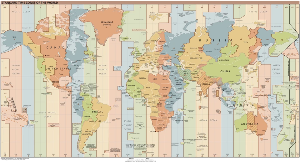
Malaysia is also wise. It comprises East and West Malaysia: East Malaysia lies in UTC+8, while West Malaysia geographically lies in UTC+7 and contains the national capital. Yet the entire country uses East Malaysia's UTC+8 time, both strengthening unity with the east and facilitating trade with China—two benefits at once. Kuala Lumpur and Chengdu are therefore in similar situations: at similar longitudes, both geographically in UTC+7, but both using UTC+8.
Among other East and Southeast Asian countries, Japan and South Korea use UTC+9; the Philippines uses UTC+8; Thailand, Vietnam, Cambodia, Laos, and the main part of Indonesia use UTC+7; and Bangladesh and Bhutan use UTC+6. These differ little from China and are easy to remember.
Most Western European countries use UTC+1, or UTC+2 during summer daylight saving time. France, Germany, Spain, Italy, Poland, and most others are fairly consistent. Spain makes the greatest adjustment: in winter dawn comes after 9:00, and in summer darkness arrives after 22:00. People therefore often eat lunch after 14:00 and dinner after 21:00.
U.S. Eastern Time matters too, because it is the time in Washington and New York. In winter it is UTC−5, thirteen hours behind Beijing. In summer it is UTC−4, exactly twelve hours opposite China, so it is easy to remember. U.S. stocks' core trading hours, for example, are 9:30–16:00. For China, the opening is at 21:30 in summer and 22:30 in winter.
India uses UTC+5:30 without daylight saving time. This is a nationally acceptable compromise, but it makes international coordination harder. When China is at 8:16, for example, India is two and a half hours behind, at 5:46. Most foreigners need a calculator for such complicated arithmetic.
References:
-
Wikipedia. Time zone [EB/OL]. Wikipedia, The Free Encyclopedia.
-
Wikipedia. Standard time [EB/OL]. Wikipedia, The Free Encyclopedia.
-
Wikipedia. Time in China [EB/OL]. Wikipedia, The Free Encyclopedia.
-
Wikipedia contributors. Time zone [G/OL]. Wikipedia, The Free Encyclopedia.
-
Wikipedia contributors. Time zones in China [G/OL]. Wikipedia, The Free Encyclopedia.
Comments
No account needed. A nickname is required; email is optional. Successful submissions appear publicly without manual pre-moderation.
Comments and nicknames are public. Optional email addresses are not displayed. The selected Waline backend and its hosting provider process comments, nicknames, optional email, IP and browser information. Comments show IP region, without the full IP address or browser and operating system labels. Hosting: Vercel; database: Neon.