Kuala Lumpur’s rail system is complicated and hard to make sense of at first glance. It also differs from systems in China in many ways. This article examines it in three parts: the overall structure, the key lines, and my experience riding it. I hope it is helpful.
I. Overall Structure: Five Types and Twelve Lines
When I first came to Kuala Lumpur, I asked a worker how to get to the metro station. I said “metro,” and he did not understand. I said “subway,” and he did not understand. I said “train,” and he still looked blank. When I opened the map on my phone and pointed, he finally understood: “MRT!”
At first I thought my pronunciation was the problem. After asking for directions a few more times, however, I found that people here all say “MRT” or “LRT,” rather than the internationally common “metro,” the American “subway,” or “underground,” as used in Britain, the former colonial power.
What exactly are these mysterious terms, MRT and LRT? They are abbreviations for two types of Kuala Lumpur rail transit: Mass Rapid Transit and Light Rail Transit. The city has other types too. Overall, Kuala Lumpur has five types of rail transit and twelve lines, generally distinguished by name and color, as listed below:
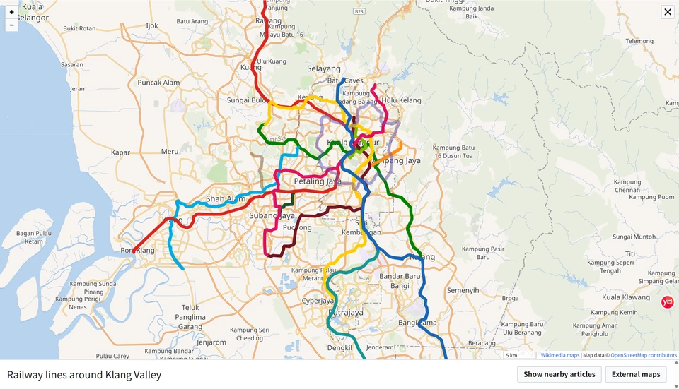
1. Mass Rapid Transit (MRT)
-
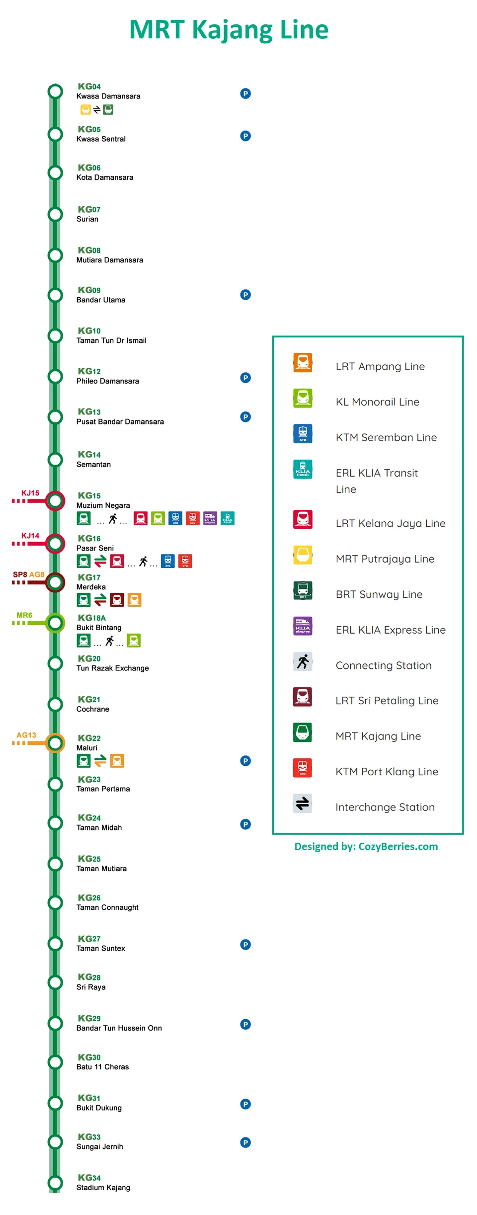
Line 9 — Kajang Line (MRT Kajang Line / Dark Green Line)
-
Termini: Kwasa Damansara ↔ Kajang
-
Key stations: Pasar Seni (Central Market), Bukit Bintang, and TRX (Tun Razak Exchange).
-
Role: A “golden trunk line” passing through central Kuala Lumpur’s commercial district and financial core.
-
-
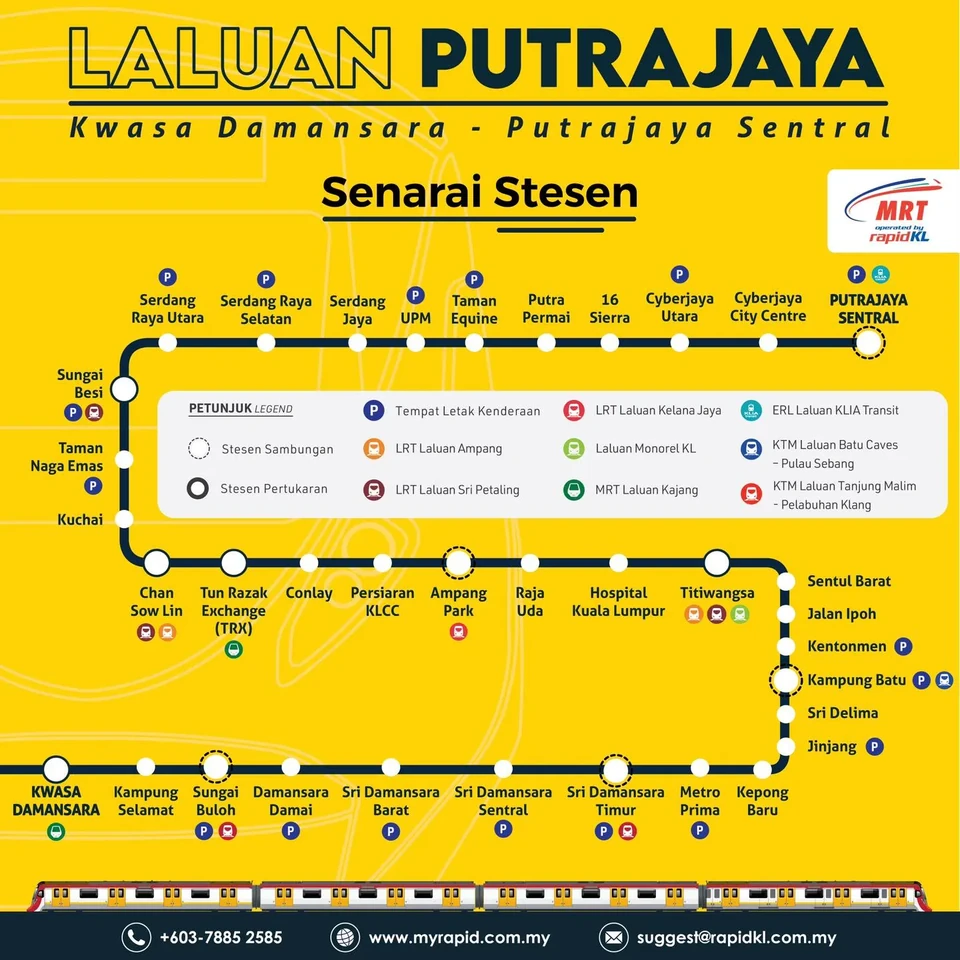
Line 12 — Putrajaya Line (MRT Putrajaya Line / Yellow Line)
-
Termini: Kwasa Damansara ↔ Putrajaya Sentral
-
Key stations: Titiwangsa, KLCC East, TRX, and Kuchai.
-
Role: A major north–south line running directly to Malaysia’s administrative center, Putrajaya.
-
2. Light Rail Transit (LRT)
-
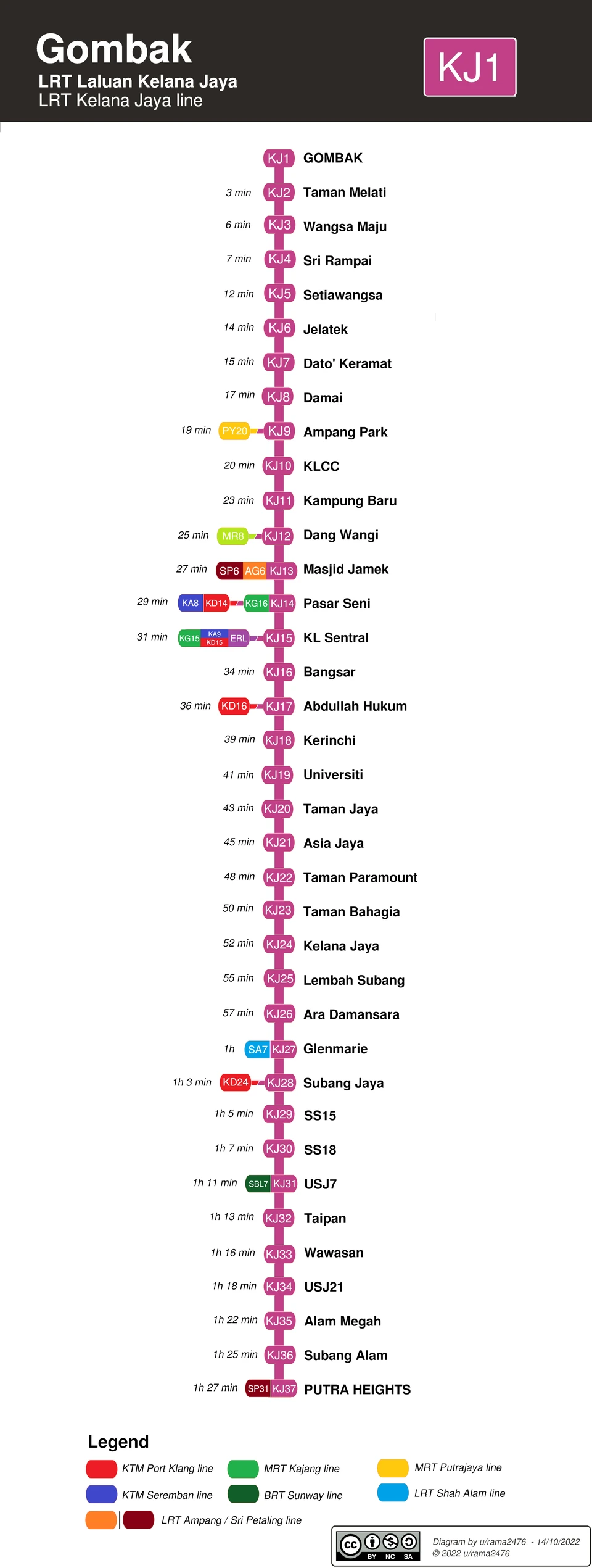
Line 5 — Kelana Jaya Line (LRT Kelana Jaya Line / Pink Line)
-
Key stations: KL Sentral, Pasar Seni, KLCC, Damai, and Subang Jaya.
-
Role: Malaysia’s busiest and most intensively used automated light rail line.
-
-
Line 3 — Ampang Line (LRT Ampang Line / Orange Line) and Line 4 — Sri Petaling Line (LRT Sri Petaling Line / Brown Line)
- Role: Connect older residential areas in eastern Kuala Lumpur (Ampang) and the south (Bukit Jalil and Srikembangan) with the city center.
-
Line 11 — Shah Alam Line (LRT Shah Alam Line / Sky Blue Line)
- Role: Connects the Klang and Shah Alam areas to the west of Kuala Lumpur.
3. City-center Monorail and Elevated Buses (Monorail)
-
Line 8 — KL Monorail (KL Monorail / Light Green Line)
-
Route: KL Sentral ↔ Titiwangsa
-
Features: Runs on elevated tracks through the core shopping district of Bukit Bintang.
-
-
BRT — Sunway Line (BRT Sunway Line / Dark Green Line)
- An electric bus system on fully elevated dedicated lanes, connecting Sunway with LRT and KTM stations.
4. Intercity and Commuter Rail (KTM Komuter)
-
Line 1 — Seremban Line (Blue Line) and Line 2 — Port Klang Line (Red Line)
-
Operator: Malayan Railways (KTMB)
-
Features: Heavy-rail commuter trains covering Selangor and neighboring states, with relatively long intervals between services.
-
5. Airport Rail (ERL — Express Rail Link)
-
Line 6 — KLIA Ekspres (Purple Line): A direct service from KL Sentral to Kuala Lumpur International Airport (KLIA T1/T2), taking about 28 minutes.
-
Line 7 — KLIA Transit (Aqua Blue Line): An airport commuter service stopping at stations including Bandar Tasik Selatan and Putrajaya Sentral.
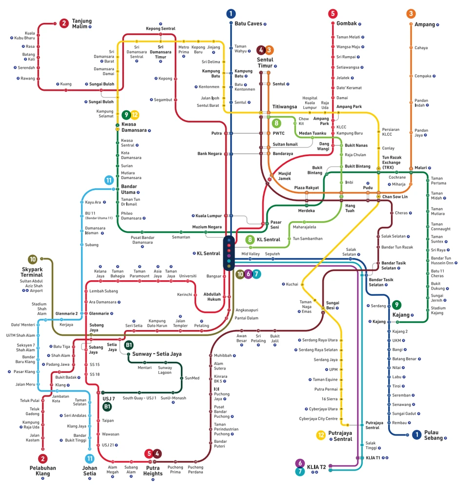 (A high-resolution map can be downloaded from Rapid’s official website: https://myrapid.com.my/bus-train/rapid-kl/rapid-kl-integrated-transit-map/#)
Rapid Rail operates the LRT, MRT, Monorail, and BRT Sunway Line. Most of the metro system is under its management, giving it the dominant position in Kuala Lumpur rail transit.
KTMB (Keretapi Tanah Melayu Berhad / Malayan Railways) operates the intercity and commuter rail services, Lines 1 and 2.
ERL (Express Rail Link Sdn Bhd / Express Rail Link Company Limited) operates the airport lines. It is a private company, so fares are very expensive: traveling from the city center to the airport costs RM55, not much less than a taxi. To save money, you can first take the Putrajaya Line to Putrajaya Sentral, then ride a section of airport Line 7, the Aqua Blue Line. This is also the cheapest route recommended on Xiaohongshu.
II. Key Lines
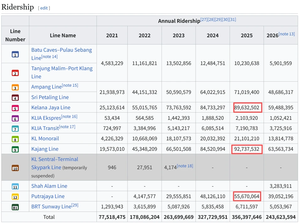
Overall, Kuala Lumpur has three particularly important rail lines with the highest ridership: Line 9, the Green Line (Kajang); Line 5, the Red Line (Kelana Jaya); and Line 12, the Yellow Line (Putrajaya). These are also the three I use most often. Lines 3 and 4 carry many passengers too, but I have not lived along them, so I will not discuss them.
Line 9 — Kajang Line (MRT Kajang Line / Dark Green Line)
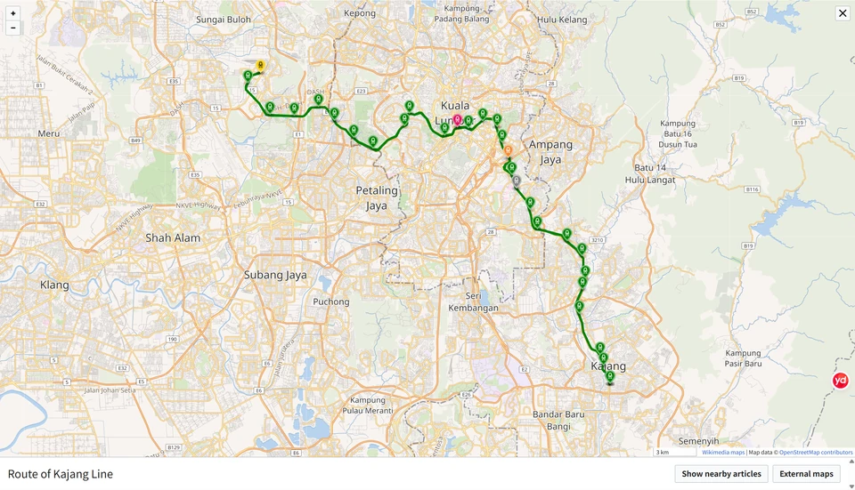
This line runs from northwest to southeast, connecting Damansara in the northwest—the affluent Damansara area and 1 Utama shopping mall—with Cheras, a large residential area in the southeast, and Kajang.
It passes through central Kuala Lumpur, serving Muzium Negara (the National Museum), Pasar Seni (Central Market), Merdeka station—beside Merdeka 118, currently the world’s second-tallest building—Bukit Bintang, where beautiful female tourists from around the world gather, TRX (Tun Razak Exchange), with its newly built mall and financial center, and Sunway Velocity at Maluri station, a commercial area with a substantial Chinese community.
I live near Maluri station in the southeast, so I use this line on almost every outing. A little after eight each morning is the worst of the rush hour. Sometimes the queue for the train stretches from downstairs to upstairs, and people pack the carriages until nobody else can fit. The spectacle is no less impressive than in Beijing.
Line 5 — Kelana Jaya Line (LRT Kelana Jaya Line / Pink Line)
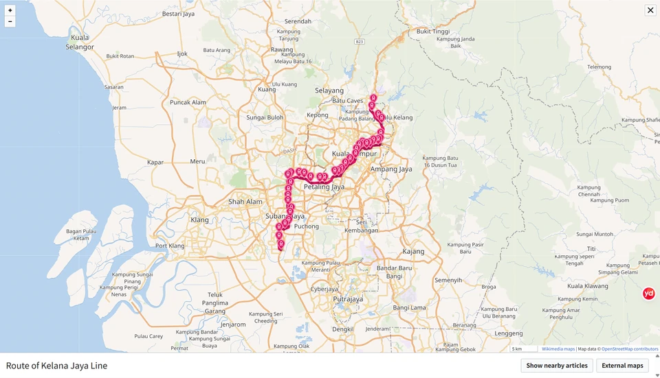
Running northeast to southwest, this line connects Kuala Lumpur’s urban area with two major satellite cities to the west, Subang Jaya and Petaling Jaya. It serves KL Sentral (Kuala Lumpur’s central station), Pasar Seni (Central Market, near Petaling Street and Merdeka Square), Masjid Jamek, and KLCC (the Petronas Twin Towers and Suria KLCC). If this is your first visit to Kuala Lumpur, this is a line you are bound to ride—or at least see, even if you do not ride it.
The line is also said to serve many universities, including the University of Malaya and Taylor’s University, as well as major companies such as Microsoft, Shopee, and Samsung. A friend of mine takes it to university every day, squeezing onto the train and having a miserable time of it.
Line 12 — Putrajaya Line (MRT Putrajaya Line / Yellow Line)
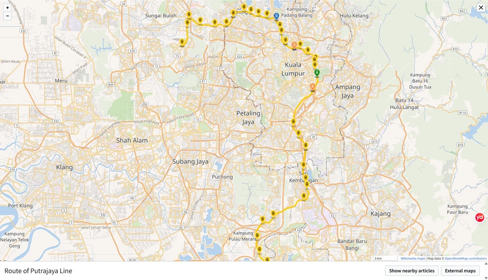
This line is Kuala Lumpur’s major north–south artery, connecting the city center with Putrajaya, Malaysia’s federal administrative center. Since Putrajaya lies between Kuala Lumpur’s airport and its city center, we can take this line to Putrajaya, then transfer to the airport rail service or an airport shuttle bus. This is the cheapest route: traveling from the center to the airport costs only about RM13, possibly less by bus. By comparison, the airport rail service costs around RM55, while a taxi may cost anywhere from RM60 to RM100.
The line mainly passes through the eastern side of the city center, serving Titiwangsa, Ampang Park, KLCC East, and TRX (Tun Razak Exchange).
III. Riding Experience
I have not used the system extensively, so I can offer only limited experience. Please add your own:
- When asking for directions, say “MRT” or “LRT.” People here do not say “metro” or “subway.”
- People here do not refer to lines by number. Although the official website assigns numbers, they do not appear inside the stations, so you have to remember colors and line names. If you say “Line 9,” people will not know what you mean; say “Kajang Line” or “Green Line,” and everyone knows. Remembering colors also makes it easier to find your way.
- There are no security checkpoints. Metro security screening may be a Chinese characteristic.
- You can use cash to buy a travel token, but you need notes of RM10 or less, or coins. Buying tokens with cash at the machines is slow, and after a while you end up with a pile of coins, so I do not recommend it.
- You can also obtain a transit card at a counter, with an issuing fee of only about RM5. It is convenient. Some counters accept cash only, while others allow Touch 'n Go (TnG).
- On escalators, people generally stand on the left and walk on the right. If you do not want to move, stay left; if you are in a hurry, go right. If you really do not want to move—or have a disability—take the lift. If you particularly want to move, take the stairs.
- Some trains have women-only carriages, so men should take care not to enter the wrong one. They are pink and quite conspicuous, but from time to time you still see men wandering in cluelessly.
- The air conditioning is very cold, with a large temperature difference between outdoors and inside the train. Older people should prepare beforehand—at least mentally—and take care not to catch a cold.
- Smoking, eating, and bringing durians are not allowed.
- If you cannot remember station names, remember their codes. Asia Jaya on the Red Line, for example, is KJ21. Starting from Pasar Seni (KJ14), you can watch the codes at each station. If you reach KJ19, there are two stations left; if you are at KJ25, you have gone four stations too far.
References
-
Wikipedia. Putrajaya Line [EB/OL]. Retrieved from the Wikipedia entry.
-
Wikipedia. Kajang Line [EB/OL]. Retrieved from the Wikipedia entry.
-
Wikipedia. Kelana Jaya Line [EB/OL]. Retrieved from the Wikipedia entry.
-
Wikipedia. Klang Valley Integrated Transit System [EB/OL]. Retrieved from the Wikipedia entry.
-
Rapid Rail Sdn Bhd. MyRapid Official Website [R/OL]. Official website: myrapid.com.my.
Comments
No account needed. A nickname is required; email is optional. Successful submissions appear publicly without manual pre-moderation.
Comments and nicknames are public. Optional email addresses are not displayed. The selected Waline backend and its hosting provider process comments, nicknames, optional email, IP and browser information. Comments show IP region, without the full IP address or browser and operating system labels. Hosting: Vercel; database: Neon.